|
|
|
|
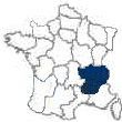
The Region of Rhône-Alpes
- France Region 22
Consists of the eight Départements of Ain [01], Ardéche [07], Drôme [26], Isère [38],
Loire [42], Rhône [69], Savoie [73] and Haute-Savoie [74]. |
 |
|
Introduction to the Region of Rhône-Alpes
Region 22 of 22
|
The Location of the Region of Rhône-Alpes
The region of Rhône-Alpes, which was established in 1980, is located in the southwestern part of France. The region is bordered by the French regions of
Burgundy and
Franche-Comté on the north,
Switzerland and Italy are to the east, the regions of
Provence-Alpes-Côte d’Azur and
Languedoc-Roussillon are to the south and the region of
Auvergne is to the west. The region is composed of the eight départements:
Ain,
Ardèche,
Drôme,
Haute-Savoie,
Isère,
Loire,
Rhône and
Savoie. The region’s capital is
Lyon and its major cities are
Annecy,
Bourg-en-Bresse,
Grenoble and
Valence.
The Geography of the Region of Rhône-Alpes
The Massif Central, which is located to the west of the generally mountaneous Rhône-Alpes region, covers the western part of the département of
Ardèche. The plain is separated from the Alpes, in the east, by are series of deep valleys that include the middle Rhône valley. The region covers most of the French Alpes. The peaks of the
Jura Mountains, to the north, cover the eastern part of the département of
Ain. The northern part of the
Rhône département, together with the département of
Isère, is a part of the lowlands of the Saône River basin.
The History of the Region of Rhône-Alpes
The northern part of the historic province of Bresse, covered most of the present départements of
Ain and Saône-et-Loire. Its capital was
Bourg-en-Bresse. It was controlled by the lords of
Vienne and the families of Antigny, Coligny and Sainte-Croix. This area was subsequently controlled by the dukes of
Burgundy. Northern Bresse, together with the rest of Burgundy, passed to the French crown with the death, in 1477, of Charles the Bold.
In the 15th century, the capital of southern Bresse was
Bourges. By the treaty of Lyons, in 1601, it was ceded to the French government. The whole of Bresse was subsequently attached to the French military government of Burgundy.
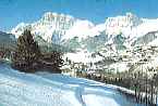
Rhône-Alpes’ principal income is the result of tourism and its numerous winter resorts. Resort towns like Avoriaz,
Chamonix-Mont-Blanc, Chamrousse, Courchevel, Flaine, Megève, Morzine and TignesVal d’Isère, feature numerous ski trails and other recreational opportunities. Other economic pursuits involve coal mining [near
Saint-Étienne and La Mure], oil refining [near Feyzin], manufacturing of metal products and synthetic fibers [near
Grenoble,
Lyon and
Saint-Étienne and along the Arve River] and a small agricultural sector. Vineyards are found along the slopes of the Rhône Valley.
The Regional Architecture of Rhône-Alpes
- The Churches
- The Chateaux
The Art of Rhône-Alpes
The Gastronomy of Rhône-Alpes
- The Wine
- The Cheese
- The Cuisine
The Economic Activity of Rhône-Alpes
- The Agriculture
- The Industry
|
Region of Rhône-Alpes, Département Information
The Départements of Rhône-Alpes
| |
Ain
The département of Ain, which was formed from a part of
Burgundy in 1790, is located in the far eastern part of France. It is positioned between the Saône River, to the west, and the Rhône River to the south. It is adjacent to
Switzerland and occupies the most northern part of the
Rhône-Alpes region. It is surrounded by the départements of Saône-et-Loire and Jura to the north,
Haute-Savoie,
Savoie and Switzerland to the east,
Isère to the south and
Rhône to the west. The département is cut in half by the Ain River, a principal supplier of hydroelectric power, which flows south to the Rhône. Its capital is
Bourg-en-Bresse.
The Jura Mountains rise in the eastern part of Ain, where the peaks of Mont Reculet and Crêt de la Neige reach more than 5640 feet. This area is covered with large forests and pastures. Considerable cattle breeding takes place there and dairy products, including cheese, are produced.
In the west of Ain are two low regions. The lowest is the Bresse plain where the rich soils support farming and livestock raising, which includes pig and poultry raising. The Dombes upland, which is used mainly for fish, geese and horse and cattle breeding, has poor soils, glacial deposits and marshlands. There is some silk production in small towns near Lyon.
On the east end of Lac de Nantua is a Benedictine abbey that was founded in the 7th or 8th century. Divonne-les-Bains is a spa and winter resort town. The walled town of Pérouges has a large number of houses dating from the 15th and 16th century. Its pride is a 12th century inn.
Ain’s economic activities include tourism, stock raising, cheese making, forest activities, small manufacturing, diamond cutting, watch making, lens crafting and precision machinery and plastics manufacturing. Calcium carbide is mined near Bellegard. The Ain and Rhône rivers supply hydroelectric power.
Ardèche
The southeastern département of Ardèche is situated in the highland on the edge of the Massif Central. It was formed from the Vivarais district of Languedoc in 1790. It is surrounded by the départements of
Loire and
Isère to the north, by
Drôme to the east, by
Gard to the south and by
Lozère and
Haute-Loire to the west. The département contains much of the volcanically created Cévennes and Vivarais mountains, which contain many warm springs. The département’s principal rivers are the Allier [which forms Ain’s eastern boundary], Ardèche, Doux, Erieux and the Rhône [which forms Ain’s eastern boundry]. Mont Mézenc, on the Velay volcanic plateau, reaches 5751 feet.
In 1629,
Louis XIII of France, destroyed the fortress town of Privas in an attempt to put down a Calvinist revolt. The rebuilt town is now the capital of Ardèche.
Agriculture is Ain’s principal activity. Fruit trees and some olive trees are grown in the lower valleys, together with the cultivation of cereal, potatoes, fodder, and grape vines.
At the higher elevations, not exceeding 2500, chestnuts are harvested. Still higher up there are summer pastures for cattle and sheep. There are cement plants located along the Rhône River valley.
Drôme
The département of
Drôme was created in 1790 from the old provinces of Provence and Dauphiné. It is located in southeast France and is bordered by the départements of
Isère to the north,
Hautes-Alpes to the east,
Alpes-de-Haute-Provence and
Vaucluse to the south and
Ardèche to the west. The Rhône River runs along its eastern border for almost 70 miles.
Valence, the capital of Drôme, is located on the Rhône River. The Drôme and Isère rivers also flow through the département.
The Autoroute du Sud cuts through Drôme along the east bank of the Rhône, the départements only navigable river. A system of
canals connects with the Rhône, and inturn, connects the Rhône with the Rhine and other navigable waterways. There are several hydroelectric power generating plants along the Rhône and at Pierrelatte. South of Montélimar is France’s most important nuclear power generating plant. Grains and fruits are cultivated in Drôme. Because of Italian and Chinese competition, the once important industry of raising silk worms, and the spinning of silk, deteriorated at the beginning of the 20th century. However, natural silk continues to be woven, both singularly and with synthetic fibers, in many of the small towns. The local vineyards are famous for their fine wines. The town of Montélimar is known for its smooth nougat.
Haute-Savoie
The département of
Haute-Savoie
was formed from the northern part of the historic duchy of Savoy. Lac Léman, and the Swiss canton of
Genève, form the northern border of Haute-Savoie. To the east is the Swiss canton of Valais and to the southeast is Mont-Blanc and the Italian border. The capital of Haute-Savoie is
Annecy.
As the Rhône River flows out of lake Léman it forms the département’s western border. Mountain peaks and the Aiguille des Glaciers of the massif of Mont-Blanc, the highest peak in the Alpes [15771 feet], run along its southern boundary, separating it from the département of
Savoie. Below Mont-Blanc, the Arve River winds it way through
Chamonix, then across the département, joining the Rhône at Geneva. The téléferique, that leaves Chamonix and crosses Mont-Blanc’s summit, on its way to Italy and Courmayeur, provides the rider with the most majestic view of the Alpes possible [there is also a 7 mile tunnel, under Mont-Blanc, between the two towns.
From Mont-Blanc, the French Alpes slope quickly to the north, towards Lac Léman, reaching an elevation of about 1000 feet at the quaint lake-shore towns of Évian-les-Bains and Thonon-les-Bains. Annecy and its lake, to the south, are surrounded by the picturesque Pre-Alpes mountains that are covered with forests and pastures.
Haute-Savoie’s agriculture consists of cereals, grape vines and fruit in the protected, lower parts. The lower area’s dairy cooperatives are large producers of cheese and other milk products.
The département is engaged in lumbering, cement making, cheese processing, engineering and watch making. Electronic and precision instrument manufacturing take place in and around Annecy; there is also a famous bell foundry. The area has a vigorous tourist industry, based upon skiing and sight seeing, that is centered about
Chamonix, and the lesser winter sport centers of La Cluzas, Megève and Morzine, in the valleys of the Mont-Blanc massif.
Isère
The mountainous département of Isère was formed, in 1790, from the northern part of the old province of Dauphiné. Isère is bordered by the départements of
Ain and
Haute-Savoie to the north,
Savoie to the east,
Hautes-Alpes to the south and
Drôme,
Ardèche and
Rhône to the west. Its capital is the mountain bound city of
Grenoble, which is situated at the confluence of the Isère and Drac rivers, in south central Isère.
To the south of the département are the peaks of the Massif de Loisans and the Massif du Pelyoux; their peaks reach some 12800 feet. The forests and wastelands of Bas Dauphiné slope into the Rhône Valley. The département has two navigable rivers, the Rhône and the Isère.
To the northeast of Grenoble are small areas of fertile farmland. The southern alpine region has broad, fertile valleys. The area’s mountains are forested as high as 6000 feet, thus facilitating a robust lumber industry. The area’s hydroelectric production has fostered considerable industry around
Grenoble, the Drac River valley and the mountain passes. Isère’s alpine beauty draws tourists all year, thus enabling both winter and summer sports as the basis for a strong tourist industry. The area is also famous for the Chartreuse liqueur that is distilled near Grenoble at the Grande Chartreuse monastery.
The département embraces the historic 16th to 17th century chateau of Vizille. Isère was the homeland to Hector Berlioz who composed, among other works, his Synphonie Fantastique.
Loire
The east-central France département of
Loire is located in the eastern part of the Massif Central. It was formed, in 1790, from the ancient Forez and parts of the old Beaujolais and Lyonnais provinces. It is encircled by the départements of Saône-et-Loire to the north,
Rhône and
Isère to the east, the Auvergne départements of
Ardèche and
Haute-Loire to the south and
Puy-de-Dome and
Allier to the west. Its capital,
Saint-Étienne, is located between the Loire River and the Rhône River.
The département is composed primarily of three plains that are surrounded by mountains and high plateaus. The plains consist of the marshy Forez, the Roanne and the Saint-Étienne. The Loire River flows through the Forez Plain, which is protected by mountain chains on both sides, practically the entire length of the département. The Forez Mountains extend about two-thirds of the way. Its tallest peak is Pierre-sur-Haute, which rises to the elevation of 5261 feet. The Madeleine Mountains then continue northward. The Lyonnais Mountains, which are to the northeast of
Saint-Étienne, segue into the Beaujolais Range to the north.
Pastoral farming is pursued on reclaimed land of the Forez Plain. On the Lyonnais and Beaujolais plains cattle farming is practiced. On the Roannais Plain one finds cattle raising and cereal cultivation.
Loire is one of the most industrialized of French départements. Saint-Étienne is the département’s manufacturing and trade center. Located along a line, running about 30 miles from northeast of Saint-Étienne to southwest of the capital, are the industrial towns of Firminy, Le Chambon, and Saint-Chamond. Another industrial center is
Roanne, which is located in the north.
At Saint-Priest-la-Prugne, southwest of Roanne, are uranium fields. The département has such heavy industry as armament, hardware and bicycle manufacturing. Coking plants, metalworks and steel mills abound in the area around Saint-Étienne. The textile industry, centered about
Lyon, is supplied by looms found throughout the Loire département.
The département has an abundant number ancient villages, châteaux and medieval churches.
Rhône
The département of Rhône was created in 1790 from the ancient area of Lyonnais. In 1967, small areas of
Ain and
Isère were added to it. It is located in the northwest of the Rhône-Alpes region of southeastern France. It is a mostly mountainous département, perched on the northeastern slopes of the Massif Central. The département is encircled by the départements of Saône-et-Loire to the north, Ain and Isère to the east, Isère to the southeast and
Loire to the south and to the west.
Lyon, France’s 3rd largest city, is the capital of both the Rhône département and the Rhône-Alpes region.
The northern half of the département, west of the Rhône and Saône plains, is covered by the Beaujolais Mountains. The southern half is covered by the Lyonnais Mountains. The Rhône River, which flows east to west through the département of
Ain, turns south at
Lyon, forming the eastern boundry of the southern half of the département of
Rhône. The Saône River, which flows north to south, mixes with the Rhône at Lyon. It forms the département’s eastern boundry for the northern half of the département.
The lands of the Rhône and Saône plains are fertile. They are used to grow cereals, sugar beets and the grapevines that produce Beaujolais wine. Much of the département’s industry is centered in and near the populous city of Lyon, which for centuries, had been a world center for the production of silk cloth. Today, its textile industry produces mostly synthetic fibers. The area is also a center for the chemical, food-processing, metallurgical and motor vehicle industries. However, the area’s largest employment is derived from the transportation industry. Lyon serves as a juncture for rail, road and water routes.
Savoie
The département of Savoie is situated in the extreme east of the region of
Rhône-Alpes in southeastern France. It was originally the southern portion of the duchy of Savoy that was returned to France in 1860. Savoie is bordered by the département of
Haute-Savoie to the north, Italy to the east, the département of
Hautes-Alpes to the south and
Isère and
Ain on the west. The land is dominated by the southwestern Alpes and the deep valleys of the Fier, Isère and Rhône rivers. The Alpes Grées separate the southeast portion of Savoie from the Piedmont Region of Italy.
The Pre-Alpes Bauges and La Grande Chartreuse ranges are located in the département’s west, on either side of the capital of
Chambéry and Lac du Bourget. Chambéry is also the seat of an archbishopric. Savoie’s eastern two-thirds contains snow capped mountains that are among the highest peaks in Europe. Contained between the Isère and Arc rivers is the Massif de la Vanoise and its 34 square miles of glaciers. The Vanoise National Park’s Pointe de la Grande Casse rises to 12638 feet.
Cattle are raised in Savoie’s high valleys. Cereals, forage crops, fruit trees and grape vines are found in the lower ones. Tourism is a big factor in the economy, and is centered around such winter resorts as Courchevel, Paralognan-la-Vanoise and Val d’Isère. Warm water spas, such as
Aix-les-Bains, are popular tourist destinations. The area’s rivers are used to generate hydroelectric power for aluminum and specialty steel plants. There are also paper plants, cement plants and electro-mechanical works.
The Region of Rhone-Alpes
Consists of the Départements of:
Ain [01], Ardeche [07], Drome [26], Isere [38], Loire [42], Rhone [69], Savoie [73] and Haute-Savoie
[74
|
|
|
|
|
|
|
|
|
|
|
|
|
|
|
|
|
|
| |
|
|
The Region of Rhône-Alpes, Town Information
The Towns of Rhône-Alpes
| |
Aix-les-Bains
Aix-les-Bains is a summer and winter Alpine spa resort, located in the département of
Savoie, southwest of
Geneva on the banks of France’s largest lake, Lac Bourget. The Romans knew the town as Aquae Gratianae. The funicular, from Aix-les-Bains, climbs the 5125 foot high Mont Reyard for a spectacular belle-view of the area.
Annecy
The ancient town of Annecy is situated on the northwestern shore of Lac Annecy. It is located 63 miles northeast of
Lyon and 32 miles south of
Geneva. Annecy is both a bishopric and the capital of
Haute-Savoie.
From the 10th century, Annecy was the capital of the counts of Genevois. From 1401 to 1860, it was a part of the Italian duchy of Savoy. In 1535, during the Reformation, the bishop’s seat, together with monastic institutions, was transferred there from Geneva. Annecy reached its zenith in the 16th century. From 1602 to 1622 Saint-Francis de Sales was bishop. There, Saint-Francis, together with Saint-Jane-Frances Chantal, founded the Convent of the Visitation of the Virgin.
Jean-Jacques Rousseau took refuge in Annecy in 1728. In 1860, Italy ceded Annecy, and the rest of
Savoie, to France.
Part of Annecy’s charm, as a tourist center, is its network of canals and arcaded streets in the old city. A popular tourist attraction is the Palais de l’Île, which is located between two branches of the Thioux River. Its industries include confections, electronics and precision instruments.
Bourg-en-Bresse
Bourg-en-Bresse is situated west of
Geneva [and the Jura], on the Revssouze River in the Bresse-Dombes lowlands. It is
Ain’s principal city.
Its well-known market flourished in the 11th century. In 1250, the town was granted a franchise charter. The dukes of Savoy made it the chief city in Bresse during the early part of the 15th century. In 1601, Bourg-en-Bresse became part of France.
Bourg-en-Bresse contains the late-Gothic Church of Brou, which was constructed in the 15th century by Margaret of Austria in memory of her husband, Philibert the Fair, Duke of Savoy. The former Brou Priory houses the Ain Museum. The choir, nave and stalls of Notre-Dame Church date from the 16th century.
Light manufacturing, farm trade, poultry raising and tourism are the mainstays of the town’s economy.
Chambéry
Chambéry is the capital of the département of
Savoie. It is located northeast of
Grenoble and 325 miles southeast of
Paris, in the Leysse Valley. The Leysse Valley lies in the center of the French Alpes, between the massifs of La Grande Chartreuse and that of Beauges.
Chambéry was begun as the Roman station of Lemincum on the Roman
transalpine route from the north across Mont Cenis Pass to Milan. It became the capital of the counts and dukes of Savoy in the 14th century. They built a fortified castle that commanded the valley from a hilltop. During 1792, the French Revolutionary government set up the département of Mont-Blanc and made Chambéry its capital. The city was occupied several times by the French. The treaties of Paris and Vienne returned it to the house of Savoy. In 1860, the citizens of Chambéry voted for separation from the house of Savoy and union with France.
The northern half of Chambéry was raised by Allied bombing during 1944. It has been rebuilt with modern buildings and wide avenues. The southern half still retains its 17th century ambience with hints of its former 15th and 16th influences.
The city boasts of a tourist attracting, 15th century Sainte-Chapelle that, between 1502 and 1578, reputedly housed the Holy Shroud. It is found within the 12th century ducal château that was rebuilt during the 15th century. There is also a large, interesting city cathedral.
Les Charmettes, the country home of Jean-Jacques Rousseau and Madame de Warens, is located 1 mile south of the city. The city’s Savoy Museum contains a collection of historical documents relating to the house of Savoy. An excellent collection of Italian paintings is displayed at the Museum of Fine Arts.
Chambéry is a regional transportation center. It is located on a primary auto and rail route and possesses a jet capable airport. Its industries include confectionary, construction materials, fiberglass, metallurgy and shoe factories. The urbanization process is having the effect of merging Chambéry with neighboring Aix-les-Bains.
Chamonix-Mont-Blanc
Chamonix-Mont-Blanc is an internationally known alpine summer and winter resort. It is situated at an elevation of 3402 feet, at the base of western Europe’s highest mountain, Mont-Blanc, that rises to 5771 feet to the southeast. It is on the Arve River, in the French Alpes of
Haute-Savoie, west of
Annecy. It is near
Switzerland and is across the mountain from Italy.
Chamonix is the base, on the French side of the mountains, for a cable-car system that climbs to a ski station near the summit of the Aiguille du Midi [12434 feet], traverses the massif and goes to the Italian town of Courmayeur on the south side of Mont-Blanc. It is one of the world’s highest cable-car systems.
Grenoble
Grenoble, the capital of the département of
Isère, is located at the foot of Mount Rachais southeast of
Lyon and 135 miles north of Marseille. It is situated on the Isère River, at the convergence of the Isère and Drac rivers.
In the 4th century BC the Allobroges, an ancient Gallic tribe, named Grenoble ‘Cularo’. The Romans later renamed it Gratianopolis, in honor of the emperor Gratian. Eventually, the name was transformed into Grenoble.
Starting in the 4th century, Grenoble was the seat of a bishopric. It was occupied by the Arabs in the 9th century. It was subsequently taken from the Arabs by the counts of Albon, and remained a part of the kingdom of
Provence until the 11th century. From the 11th to the 13th century, it was the capital of the independent country of Dauphiné. It passed to France, together with the rest of Dauphiné, in 1349. During the Wars of Religion, as well as after the
Edict of Nantes was revoked, things did not go well in Grenoble. In 1788, the town rebelled against the limitation of the local parliament’s powers by the French crown. In 1815 it became
Napoleon I’s stronghold following his return from Elba. During the course of the German occupation, during World War II, Grenoble was the site of considerable French resistance. In 1968, Grenoble hosted the winter Olympic games.
The oldest part of Grenoble is located on the right bank, between the river and the mountains. There are many old ecclesiastical structures in this part of the city. There is the 11th century Church of Saint-Laurent, the partially 11th century Cathedral of Notre Dame, the 11th century Carthusian monastery La Grande Chartreuse and the 13th century Church of Saint-André. The Dauphinois Parliament formerly occupied the 16th century Palais de Justice. The
University of Grenoble was founded in 1339 and was reorganized in 1970. The university has become noted for its research into physics.
The major part of the city is spread over the plain on the left bank. There is a museum of village life, known as the House of Culture. Together with the sports stadium, it is an interesting example of French contempory architecture. Grenoble has a particularly fine museum of fine arts. There is also a museum housing both a renowned gallery of modern paintings and a rich collection of manuscripts. It includes most of the manuscripts of the well-known 19th century French writer Stendhal who was born in Grenoble in 1783.
The 19th century Bastille fortification is perched upon a hill overlooking the city. It is reached by cable-car.
The city is a cultural, research and industrial center. It is an important center for France’s telecommunications industry. The nearby hydroelectric power generation, from Alpine rivers of the area, provides the energy base for high-energy nuclear-physics research, the manufacture of electrical equipment and machinery, electrometallurgy, cement, chemicals, leather goods, paper, textiles, turbines, processed food and plastics. The city abounds with scientific research laboratories. It is also a tourist center due its numerous medieval buildings, the nearby winter sports facilities and natural parks
The Capital of Rhône-Alpes - Lyon
Lyon [also spelled Lyons] is the capital of the
département of Rhône and of the region of
Rhône-Alpes. It is the third largest French city, following
Paris and
Marseille; however, its metropolitan area ranks second to only Paris’ as to economic importance and size. It is centered, with its main commercial and entertainment district, on a peninsula between the Saône and Rhône rivers. The town spreads onto the steep hills on both banks of the river. The rivers are navigable and are bordered by many docks and warehouses. The rivers have divided the city into three parts and are spanned by many fine bridges.
- The Capital’s Location
-
The Capital’s History
Lyon was founded in 43 BC as a Roman military colony called Lugdunum. By the 2nd century AD,
Augustus had made it a major city and the capital of ancient Gaul. Latter, the town was ravished by the barbarians and abandoned by the Romans.
Lyon had been the focal point of the introduction of Christianity in Gaul during the 2nd century. It was during that time that the Roman emperors Marcus Aurelius and Lucius Septimius Severus persecuted the Christian community. The Burgundians made Lyon their capital in the later half of the 5th century. In 1032, Lyon was incorporated into the Holy Roman Empire. It remained a religious center that was ruled by its powerful archbishop until Lyon was annexed, in 1307, by the French crown. During that period, in 1245 and again in 1274, the town was the site of two ecumenical councils.
By the end of the 14th century silk manufacturing had been introduced to the city from Italy. Lyon soon become renowned for its silk industry that brought it long lasting prosperity; special fibers are still hand-woven there. By the 15th century, Lyon had become an important center of commerce and trade. But, during the French revolution it suffered economically and did not regain its prominence until the early 20th century. The area experienced depression and stagnation between 1920 and the end of World War II.
World War II, and the German occupation, saw Lyon as a resistance center that consequently suffered great damage. In 1944, as the result of a joint campaign by the French resistance and the French and American armies, it was freed of the Germans. In 1998, many historical buildings, together with the old quarter, were designated as UNESCO World Heritage Sites.
Vieux [Old] Lyon is located along the Fourvière ridge, on the right [west] bank of the Saône. It is a picturesque quartier, with towering mansions and narrow streets. It is one of the finest surviving architectural complexes of the Renaissance. The Basilica of Norte Dame de Fourvière was erected there during the period 1871 to 1894.
The east bank of the Rhône is the newest part of Lyon. It includes a university and a district with worker’s housing and factories that extends toward the nearby communities of Bron and Villeurbane. The Brotteaux, on the east bank of the Rhône, is a wealthy neighborhood.
The city boasts of two Roman amphitheaters and many fine museums and buildings. Among the museums is the Museum of the History of Textiles that houses collections of textiles from all over the world. There are materials from all periods and regions. The city’s Museum of Contemporary Art, which was designed by the Italian Renzo Piano, opened in 1995. The 11th century Church of Saint-Martin d’Ainey and the 11th century Cathedral of Saint-Jean are outstanding examples of the city’s beautiful buildings.
The
University of Lyon was founded in 1808. It has three separate campuses: the
University Claude-Bernard [Lyon I], the
University of Lyon II and the
University Jean Moulin [Lyon III]. The university has schools of law, letters, medicine, pharmacy and science.
Today, Lyon is an important inland port and industrial center. It is connected with
Marseille by both rivers and canals. Its manufacturing is diversified. It encompasses chemicals, electrical equipment, machinery, motor vehicles, printing [which was introduced as early as 1473] and textiles. Along the Rhône, to the south, are the oil-refining complexes of Fayzin and Saint-Fons. They are among the largest petrol-chemical facilities in France. There is an annual spring international trade fair that is hosted by the city. The fair was actually begun in 1464 when Italian merchant bankers facilitated the city’s commercial expansion. Today, Lyon is one of France’s most important financial centers, possessing France’s oldest stock exchange.
In 1978, Lyon opened its first subway line. In 1981, it became the first French city to be linked to
Paris by the high-speed Train à Grande Vitesse [TGV].
Lyon has long been known for its fine cuisine. One of the world’s finest chiefs,
Paul Bocuse, has a restaurant here in one of the suburbs. Its agricultural products include wine and cheese.
Privas
Roanne
Roanne is an industrial town and river port situated on the left bank of the Loire River in the département of
Loire. It is located 42 miles west-northwest of
Lyon and 208 miles southeast of
Paris. The Loire gorges are 2 miles to the south. Several miles to the west are the scenic Madeleine Mountains. The town is strategically placed at a juncture of roads and railroads and at the terminus of the Canal de Roanne à Digoin.
Roanne was originally a Roman town called Rodumna, the center of a network of Roman roads. There are still remnants of a medieval castle in the town. Only its 11th century tower and the donjon remain. There are also a few 15th and 16th century houses. The center of town is known as the Carrefour Helvétique [Helvetian Crossroads]. The former 17th century Jesuit college is now the Lycée Jean Puy.
The town has a small tourist industry predicated upon visits to the Loire River gorges. The town’s traditional industries are hat making, machine tooling, metal working and textiles. Its traditional industries are augmented by the manufacture of armored vehicles, paper, rubber tires and synthetic fabrics.
Saint-Étienne
The capital of the département of the
Loire is Saint-Étienne. It is located on the northeastern border of the Massif Central, about 30 miles southwest of
Lyon. It is the center of an industrial area that is spread through the adjacent Gier and Ordaine valleys.
The town was originally settled on a coal basin around 1195. It derived its name from the community’s small church of Saint-Étienne. As early as the 12th century, the town’s blacksmiths are believed to have used surface coal. During the 15th and 16th centuries, Saint-Étienne became an important economic center. The manufacture of firearms was established there, in the 16th century, by king
Francis I. An important silk industry was also initiated there. In 1815, France’s first steel mill, which was imported from England, was built at nearby Le Chambon. In 1832, it became a rail terminus for the coal transporting railroad from Lyon to Saint-Étienne. This was Europe’s first railroad. In 1886, the manufacturing of bicycles was introduced from England.
The University of Saint-Étienne was founded in1969. There is a large exhibition of arms located in the town’s Palais des Arts.
The town specializes in the manufacture of steel for arms and for armor plating. It also engages in the manufacturing of bicycles, dyeing, glass making and woodworking. The town is famous for its silk ribbons [which have been manufactured there since the 16th century], scarves and ties. It is the home of ‘Casino’ stores, France’s largest commercial company.
Valence
The town of Valence is the capital of the département of
Drôme. It is built on a series of terraces, along the left bank of the Rhône River, 60 miles south of
Lyon and 480 miles southeast of
Paris. Valence was founded by the Romans, in 123 BC, who called it Valentia Julia.
Successive barbarian invasions left the town ravaged. It was subsequently ruled by the Burgundians, the Franks, the kings of
Arles and the counts of
Toulouse. In the 4th century, the town became a bishopric and, as the capital of the duchy of Valentinois, it was ruled, until the 5th century, by its bishops. In 1450, king
Louis XI, of France, persuaded the bishops to exchange their temporal power for the protection of the crown.
Pope Urban II consecrated the Romanesque styled Cathedral of Saint-Apollinaire in 1095, but it wasn’t completed until early in the 12th century. The cathedral was seriously damaged during the Wars of Religion that took place from 1569 to 1598. It wasn’t repaired until the 17th century. To the south of the cathedral is an esplanade known as the Champ de Mars. It offers an enchanting view of the Rhône River valley. The nearby Maison des Têtes is decorated with sculptured heads.
Valence is the area’s market center where there is a brisk trade in fruits, vegetables and wine. Its manufactured products are jewelry and textiles.
Vienne
The historic town of Vienne, in the département of
Isère, is on the east bank of the Rhône River, 260 miles southeast of
Paris and 16 miles south of
Lyon. The old town is surrounded by steep hills.
In 47 BC,
Julius Caesar established the town of ‘Vienna’ as a Roman colony. It had been the ancient capital of a Celtic tribe known as the Allobroges. From 259 to 269 AD, Vienna was the capital of Provincia Viennensis, one of the two independent Gallic domains. Roman rule in the area ended in 275 AD.
In 438 AD the Germanic tribe, called the Bourguignons, took the town. A century latter, the town was dominated by the Franks. Later, Charles II, the Holy Roman emperor, gave Vienne to the king of
Provence. In 933, it became part of the Bourguignon kingdom of
Arles. Late in the 9th century, the town became part of the Holy Roman Empire. The Dauphins, so called because of their coat of arms, ceded the area to France in 1349. As a consequence, the oldest son of the French kings ruled the area. He was known as the
Dauphin.
The many Roman monuments to Vienne’s historical past include the following ruins: a theater [built on the slopes of nearby Mount Pipet and could seat more than 13000 – it is still used], an aqueduct, the Forum’s portico, the pyramid surmounted upon the arch at the site of the circus and the Roman Temple of Augustus and Livia that dates from the early 1st century AD. In the 5th century, the temple became a Christian church. During the French Revolution it was used as a club for the Jacobins. It was restored in 1860.
The former Abbey Church of Saint-Pierre, which contains a lapidary museum with Roman relics, dates from the 4th century and is one of the oldest churches in France. The church of Saint-André-le-Bas, near the Rhône Bridge, has a fine spire and cloisters dating from the 12th century. The Cathedral of Saint-Maurice, which also dates from the 12th century, and which was finally finished in the 16th century, has a fine late Gothic portal. Its nave contains interesting sculptures and tomb slabs. Saint-Maurice is the town’s largest church.
During the 1960s and 70s, excavations in the center of the town uncovered the walls of a theater and a temple consecrated to the Eastern divinity Cybele. An excavation, covering more than 10 acres on the right bank of the Rhône, uncovered Roman residential and commercial structures.
Vienne is noted for the fruits that are grown in the nearby Rhône Valley. Its industries include footwear, metallurgy and textiles.
|
|
|
|
|
|