|
|
|
|
|
|
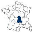
The Region of Auvergne
-
France Region 3
The Region of Auvergne - Region 3 of
22
France Regions |
|
 |
|
|
|
The region of Auvergne is located in central France.
The region is surrounded by the regions of
Bourgogne to its north,
Centre to its northwest and west,
Midi-Pyrenees to its southwest,
Languedoc-Roussillon to its south and
Rhone-Alpes to its east.
Auvergne is composed of four départements.
The département of
Allier [03], is located in the north,
Cantal [15], in the southwest,
Haute-Loire [43], in the southwest and
Puy-de-Dome [63], in the region’s center.
The capital of Auvergne is the city of
Clermont-Ferrand.
Return to Top
The Location of Auvergne
The region of Auvergne is found in France’s Massif Central.
The Massif Central is a large, somewhat arid upland area of south central France.
It covers about one-sixth of France’s area and, at Puy de Sancy, it reaches an elevation of 6188 feet.
Puy is the French word for a volcanic summit.
The Massif Central’s land area encompasses all, or part of the regions of Auvergne, which is located in the center of the Massif,
Midi-Pyrénées and
Limousin.
Saint-Étienne,
Clermont-Ferrand, and Limoges are major industrial centers. Besides heavy industry, the region supports sheep and goat raising, dairy farming, and coal and kaolin mining.
Several major hydroelectric facilities also are here, notably on the Cère, Dordogne, Lot, Tarn, and Truyère rivers.
The Auvergne Mountains are the source of the Dordogne River, just south of Monts Dore in the region of Auvergne.
At first it flows southwest and then turns west, in the region of Limousin, département of
Corrèze, for a total length of about 300 miles.
It combines with the Garonne River and enters the Gironde estuary near Bordeaux. The longest tributary of the Dordogne is the Isle River, which joins it at Libourne, the head of navigation for seagoing ships.
Return to Top
The History of Auvergne
The region of Auvergne consists of the former province of Auvergne.
The province took its name from the Arverni, a Gallic tribe whose leader,
Vercingetorix, was defeated by Roman general Gaius Julius Caesar.
The Gallic capital, called Gergovia, was destroyed, by the Romans, and replaced by the colony of Augusto-Nemetum, which later became Clermont.
Auvergne was included in the newly conquered land, in southwestern France, that Caesar called Aquitaine.
In 475, the Romans ceded Auvergne to the Visigoths.
In 507, Auvergne was conquered by the Frankish king
Clovis I.
In about 928, Auvergne became the possession of the Count of Toulouse; It was subsequently ruled by the Count of Poitiers.
In the 12th century, Auvergne became a possession of the English king,
Henry II, upon his marriage to
Eleanor of Aquitaine, heiress of Auvergne.
From the end of the 13th century, the area of Auvergne, bounded by the Allier and Coux Rivers, became known as the Dauphiné d’Auvergne.
In 1360,
John II of France made the area known as the
Terre d’Auvergn into a duchy for his son Jean, Duke de Berry.
With
the end of
the Hundred Years’ War, in 1453, the English had been driven from France.
In 1503, when Charles, the Constable of France became the Duke de Bourbon, he united the Dauphiné and the duchy.
After Charles’ treason, the domains were confiscated by
King Francis I and given, for life, to his mother, Louise of Savoy.
The domain was annexed to the kingdom of France in 1532.
The domains, which constituted the Bourbonnais province, became known as the Countship of Auvergne.
In 1551, Catherine de Médicis took possession of the Countship and of Clermont.
Once again, in 1615, after the death of Catherine’s daughter Margaret of Valois, this domain was annexed to the Kingdom of France.
In 1790, the modern départements of
Puy-de-Dôme,
Cantal, and part of
Haute-Loire were formed from the old province of Auvergne.
In the same year, the département of
Allier was formed from what used to be the province of Bourbonnais and part of the old province of Auvergne.
Return to Top
The Architecture of Auvergne
-
The Churches
The French Romanesque schools of architecture are characterized by a varied use of vaulted styles.
The introduction of vaulting led to the general use of heavy walls and piers in place of the light walls and columns that had sufficed to support wooden roofs. In the mature Romanesque style, especially as practiced in France, the use of massive walls and piers, as supports for the heavy stone vaults, resulted in a typical building plan that treated the entire structure as a complex composed of smaller units.
These units, called bays, are the square or rectangular spaces enclosed by groin vaults; late Romanesque architects tended to use these bays as their basic building unit, and these separate rectangular bays became a characteristic and distinguishing feature of the Romanesque style.
Massiveness in stone structures is another major characteristic of Romanesque architecture. The nave, in Romanesque churches, was usually made higher and narrower than in earlier structures.
This was done to make room for windows, called clerestory windows, in the sidewalls below the vault.
The doors and windows were usually capped by round arches or slightly pointed arches. These openings were generally small and were decorated with moldings, carvings, and sculptures that became increasingly rich and varied as the Romanesque period drew to a close.
In the region of
Aquitaine, in southwestern France, architects adopted the Byzantine structural principle.
This consisted of vaulting the nave with a series of domes.
Illustrations of this approach can be seen in the Church of Saint Front, at Périgueux (begun 1120), and in the 12th century cathedrals at
Cahors and
Angoulême.
Characteristic features include pointed domes and facades decorated with tiers of wall arcades filled with sculpture.
The school of ecclesiastical architecture that developed in the Auvergne region, in south-central France, represents a provincial development of the Bourguignon school. It is important for its varied experiments in solving the vaulting problems in the various pilgrimage churches. The result of these experiments was the ensuing chevet design.
The chevet design used a long choir with side aisles and a semicircular aisle flowing behind the sanctuary.
The semicircular aisle, called an arcaded ambulatory, had a number of small chapels radiating from it.
Early examples of this approach can be found in the Church of Saint Sernin and the Church of Saint Martin.
The former was built in the period 1080-1120 at
Toulouse, in the region and former province of Languedoc in southern France.
The latter, the Church of Saint Martin, was constructed from 1000-1150 at
Tours. This design approach was later adopted, and elaborated upon, in the Gothic style.
Saint Sernin is also notable for its imposing central tower.
The tower was finished well after the church itself.
It was built with a barrel-vaulted nave, symmetrical composition, and rich details.
Large-scale stone sculptural decorations became common throughout Europe in the 12th century. In the French Romanesque churches of
Provence,
Burgundy, and
Aquitaine, extensive sculptures were employed on the facades.
It is not uncommon to see statues on engaged columns that give visual emphasis to the vertical supporting members.
Notable examples of French architectural sculpture, which are almost in their original state, can be seen at the cathedrals in Toulouse, Autun, and
Poitiers. Their composition and subject matter are the direct precursors of the Gothic masterpieces at
Chartres,
Amiens, and other French Gothic cathedrals.
Return to Top
-
The Chateaux
The chateaux at Bourbon-l'Archambault, in the département of
Allier, was the seat of the first Bourbon lords.
There are other medieval buildings that are worth seeing at Ébreuil, Gannat, Huriel, Moulins, Saint-Menoux, Saint-Pourçain-sur-Sioule, Souvigny, Veauce and Ygrande.
Return to Top
The Gastronomy of Auvergne
-
The Wine of Auvergne
-
The Cheese of Auvergne
Two cheeses, Fourme and Bleu d'Auvergne come from the département of Cantal.
The milk of 30 cows goes into the making of one 50 kilo wheel of cheese.
-
The Cuisine of Auvergne
Return to Top
The Economic Activity of Auvergne
-
The Agriculture of Auvergne
Animal husbandry predominates in the mountains.
The rich plains of Limagnes, in
Haute-Loire and
Puy-de-Dôme, produce wheat, and other cereals, cattle and fodder.
Viticulture is in decline and tree farming is increasing.
Small farms in the crystalline massif of the east produce rye.
Fodder and potatoes are grown in the lowlands of
Cantal. Uranium is mined in the northwest corner of Cantal near Bort-les-Orgues. Some of the many thermal springs, notably those of Chaudes-Aigues, are developed as spas; some of the spas have begun to add facilities for winter sports.
Return to Top
-
The Industry of Auvergne
Traditional artisanship has largely disappeared in Auvergne, although cutlery continues to be produced in the town of Thiers in the département of Puy-de-Dôme. Lace making still, but barely survives in
Le Puy-en-Velay.
Manufacturing is concentrated in Clermont-Ferrand, in the département of Puy-de-Dôme, which emerged as a major industrial center in the late 19th century, and in the département of
Allier, which has benefited from its proximity to Paris.
The Michelin plant in Clermont-Ferrand is France's largest producer of tires; the industrial complex of Montluçon-Commentry, in Allier, also manufactures tires as well as computers and machines.
Spas are also important to the economic life of this region: the thermal springs of
Vichy, Néris-les-Bains, Bourbon-l'Archambault, Royat, and many other towns draw large numbers of visitors to the region.
Le Puy-en-Velay, in the département of
Haute-Loire, is a place of pilgrimage and a center for tourists who visit the département for its magnificent landscape, in which churches and castles crown volcanic peaks and hills.
Tourism is important to the département of Puy-le-Dôme. The mountain spas and winter sports resorts attract numerous visitors. Puy-de-Dôme is noted for its Romanesque churches, including those of Issoire, Saint-Nectaire, and Orcival and the Cathedral of
Clermont-Ferrand. The basalt Gergovia Plateau south of Clermont-Ferrand, where in 52 BC the Gallic chieftain
Vercingetorix repulsed Julius Caesar during the
Roman conquest of Gaul, is an historic monument.
Return to Top
|
The Region of Auvergne - Départements
|
|
Allier
The département of Allier,
lies on the northern rim of the Massif Central.
Allier was formed from the old province of Bourbonnais and part of the old province of Auvergne. Allier is bounded on the northeast by the Loire River, and the Cher River flows parallel to the Allier across the département's western portion. Allier is traversed from south to north by the Allier River.
Livestock is raised in the north-central part of the département. The Limagne Bourbonnais, in the south-central part of the département, is fertile and well cultivated.
Cantal
The département
of Cantal,is located in the higher, southern portion of the ancient province of Auvergne.
Cantal is located on the edge of the Massif Central.
At its center is a symmetrical volcanic mass called the Massif Cantal, which culminates in the 6096 foot high precipice known as the Plomb du Cantal. Sheets of solidified lava flow extend from the central core southeast and north. Streams arise and radiate to the Allier, Dordogne, and Truyère rivers, cutting through the volcanic rock and forming passes at the valley heads. The rivers are a source of hydroelectric power.
In the high country an alpine pastoral economy prevails. The cattle graze on upland pastures (aigades) from May to September. The herdsmen summer in low stone burons (seasonal shelters) where the Cantal cheeses are also made. the milk of 30 cows going into one 50-kilogram (110-pound) wheel of cheese.
Return to Top
Haute-Loire
The département of
Haute-Loire,
was created chiefly from the Velay district of the historic province of
Languedoc and from a part of eastern
Auvergne. With an average elevation of 3,000 feet (900 m), it occupies some of the wildest regions of the Massif Central and contains some of its highest mountains. The upper Loire River, flowing northeastward, waters the eastern half of the département, while the upper Allier River, flowing northwestward, waters its western section. They are divided in the south by the Devès chain and in the north by the Livradois Mountains. Le
Puy-en-Velay, the départemental capital and former capital of Velay, lies at an elevation of more than 2,000 feet at the center of a small, fertile basin.
Among the features are the crater lake of Le Bouchet, the gorges of the Loire and the Allier Rivers, and the numerous medieval churches--made of the local volcanic lavas in different colors--which include Saint-Robert in La Chaise-Dieu, the Basilica of Saint-Julien in Brioude, and two Romanesque churches in Le Puy-en-Velay: Saint-Michel d'Aiguilhe and Notre-Dame-du-Puy. The latter possesses a celebrated "Black Virgin".
Return to Top
Puy-de-Dôme
The département of
Haute-Loire,
was created chiefly from the Velay district of the historic province of Languedoc and from a part of eastern Auvergne. With an average elevation of 3,000 feet (900 m), it occupies some of the wildest regions of the Massif Central and contains some of its highest mountains. The upper Loire River, flowing northeastward, waters the eastern half of the département, while the upper Allier River, flowing northwestward, waters its western section. They are divided in the south by the Devès chain and in the north by the Livradois Mountains. Le
Puy-en-Velay, the départemental capital and former capital of Velay, lies at an elevation of more than 2,000 feet at the center of a small, fertile basin.
Among the features are the crater lake of Le Bouchet, the gorges of the Loire and the Allier, and the numerous medieval churches--made of the local volcanic lavas in different colours--which include Saint-Robert in La Chaise-Dieu, the Basilica of Saint-Julien in Brioude, and two Romanesque churches in Le Puy-en-Velay: Saint-Michel d'Aiguilhe and Notre-Dame-du-Puy. The latter posesses a celebrated "Black Virgin".
Return to Top |
|
| |
The Region of Auvergne
Cities/Towns by Departement |
|
|
|
|
|
|
|
|
|
|
| |
|
Auvergne's
Major Cities/Towns |
|
Aurillac
Aurillac is the
administrative center of the département
of Cantal.
It is situated, at an elevation of 2,040
feet, southwest of
Clermont-Ferrand on the Jourdanne River.
Sylvester II, the first French pope, was born near Aurillac.
He was educated at the nearby abbey of Saint-Gérauld that was founded in 894.
He was credited with the invention of the
pendulum clock and with the introduction of the use
of Arabic numerals into western Europe.
During the 16th century Religious Wars there was a general massacre of the Huguenots by the Roman Catholics.
In revenge, the Huguenots sacked and burned Aurillac, slaughtering its Catholics inhabitants.
Aurillac is a commercial and tourist center in upper Auvergne. It is known for its cattle and dairy markets and for the light manufacturing industry.
Some of its products are umbrellas, furniture, food processing and pharmaceuticals.
The church of Notre-Dame-aux-Neiges stands in the main square of the old town, surrounded by narrow, twisting streets.
Its Gothic architecture dates from 1339.
The Aurillac castle, which has an 11th century dungeon is now a school.
Return to Top
Clermont-Ferrand
Clermont-Ferrand is the historic capital of both the département of
Puy-de-Dôme and the region of
Auvergne.
It is located west of Lyon on the Tretaine River. To the east, the town looks out onto the Limagne Plain.
To the north, west and south, it is surrounded by hills.
Augustonemetum was Roman name for the town the Romans built on the site of the capital of the Gallic
Arverni tribe, which is now known as Clermont-Ferrand.
The Arverni were converted to Christianity in the 3rd or 4th century AD by Saint Austremonius, who became the first bishop of Clermont.
Its bishopric gave it great ecclesiastical importance during the Middle Ages
In the 9th century it became known as Clarus Mons and, in 1731, it was merged with the 11th century town of Montferrand, thus becoming
Clermont-Ferrand.
Under the
Caroligians, Clermont-Ferrand was the seat of a
countship.
From 886 to 918, William the Pious was the
ruling count.
After his rule, the viscounts of Clermont
usurped the hereditary title of counts of Auvergne.
In the 19th century the town
grew into a large manufacturing center.
The city is now highly industrialized, producing processed foods, furniture, clothing, linen, electronic equipment, bicycles, heavy machinery, precision tools, chemicals and rubber products.
The Michelin Tire Company, which is one of the largest employers in the area, is located there.
There is a nearby airport located at Aulnat.
The city is noted for its picturesque Renaissance houses and its Romanesque ecclesiastical architecture.
The church of Notre Dame du Port, which was built in 1150, and the 13th century cathedral are among its architectural attractions.
Notre-Dame-du-Port is an interesting example of Auvergnat Romanesque architecture.
The cathedral is mostly built of dark volcanic rock.
The same rock was the building material of choice for the construction of most of the houses in the old town of Clermont.
The 6th century historian, Saint Gregory of Tours, was born here as was the philosopher-mathematician Blaise Pascal, who was born in 1623.
The Renaissance Maison des Architectes houses the Musée du Ranquet, which is devoted to both the town's history and to Pascal.
The city also boasts of the universities of Clermont-Ferrand I and II.
The university was started in 1810.
Return to Top
Le Puy-en-Velay
Le Puy-en-Velay, which until 1998 was called Le Puy, is the capital of the département of
Haute-Loire.
The Romans called it Anicium.
It is located near the Loire River, on the Massif Central, about 66 miles southwest of Lyon.
The town of Le Puy-en-Velay is surrounded by an area bristling with volcanic peaks.
It is one of the most picturesque cities in France.
By the 4th century, Le Puy had become a Christian center.
During the 6th century Muslim invasion of the area the bishop of a nearby town sought refuge there.
Subsequently, the town became one of France’s pilgrimage centers.
In the latter half of the 16th century the
town sided with the Catholic League during the Wars
of Religion.
Of note is the red cast-iron, 53 foot high statue of Our Lady of France that was erected in 1860 on the town’s highest hill.
Below it, in the Old Town, is the 11th to 12th century Romanesque Cathedral of Notre-Dame that has a decided Byzantine influence.
The Byzantine affect is seen in the file of octagonal cupolas (or domes) and their decoration.
The cathedral also has zebra work in the masonry.
A similar Byzantine influence, also representing Muslim motifs that came by way of Spain, can also be seen in Burgundy.
Along side the Cathedral of Notre-Dame is a Romanesque cloister with Carolingian capitals.
At the edge of town is a 260 foot high volcanic needle with the 10th – 11th century chapel of Saint-Michel d’Aiguilhe purched upon it.
The church was ingeniously designed and constructed upon the rock’s irregular surfaces. The ruins of the 14th century castle of Polignac are located on a basalt plateau about 3 miles away.
Le Puy has been a lace-making center since the 17th century.
Currently, the town’s lace making is in decline.
The Crozatier Museum has a substantial lace collection.
Return to Top
Montluçon
Montluçon is located in the département of
Allier, northwest of
Clermont-Ferrand.
It sits on the Cher River a little below the point where it emerges from the gorges of its upper course.
Montluçon’s old town surrounds a chateau that is perched on a hill.
New districts have surrounded the old town and have spread to both banks of the Cher. The old town has a number of 15th and 16th century wooden houses nestled among its winding streets.
A museum is now quartered in the 15th and 16th century Chateau that belonged to the dukes of Bourbon.
The town’s library is housed in a former convent.
Montluçon is an industrial, commercial, and administrative centre, with metallurgical works, plastics, tire, electrical, and chemical factories.
Return to Top
Moulins
Moulins is the capital of the département of
Allier.
Moulins is located on the Allier River northwest of Lyon.
Principal among the town’s tourist attractions is its Flamboyant Gothic Cathedral of Notre-Dame.
This 16th to 17th century structure houses the 15th century triptych by the painter Jean Perréal, of Lyon, who was known as the Master of Moulins.
The cathedral’s stained-glass windows are from the same period.
Across from the cathedral is the town’s library containing a wonderful illuminated 12th century manuscript from nearby Souvigny Priory, which is located 7 miles to the southeast.
In a Nearby 15th century tower is a Jaquemart automated clock.
The chateau of the dukes of Bourbon is the town’s prison.
Moulins is an agricultural market town with some light manufacturing.
Current products are footwear, food processing and appliances.
Return to Top
Riom
Riom, which was the capital of the country of Auvergne during the Middle ages, is located just north of
Clermont-Ferrand on the Ambène River.
It is at the western edge of the Limagne Plain.
When Auvergne became a part of France, Riom continued to be the seat of the judiciary for the province of Auvergne.
Today, the old town, that surrounds the ancient church of Saint-Amable, is encircled by the wide boulevards that replaced the town’s ramparts.
In 1942, the Vichy collaborative government of
Marchal Petin set up a supreme court of justice to try two former premiers of the Third French Republic, and others:
Leon Blum and Edouard Daladier (Paul Reynaud, an other former premier of the Republic was not tried). General Maurice Gamelin was also a defendant.
They were tried, by Vichy, for their responsibility in the German defeat of France.
The trial began in
Riom on February 19, 1942.
This process marked the beginning of Vichy’s decline in prestige; the coup de grace to Vichy’s prestige was the strong British Commando raid on Saint-Nazaire, and its consequences, on March 27, 1942.
Germany seized Vichy France on November 11, 1942.
Pharmaceuticals and tobacco products are manufactured in Riom.
Return to Top
Vichy
Vichy, which was known to the Romans as Vicus Calidus, is the best known health spa in France.
It is situated on the Allier River. Its two largest hot water spa centers face the river.
They are separated from the town by the parks that surround them.
The town has the appearance of being modern with more than its share of hotels.
Due to its alkaline springs and spas, Vichy had become famous by the 17th century.
The Vichy spas were long the favorites of the European royalty for ‘taking the waters’.
The French kings followed an almost ritual pattern for their visits to Vichy, and this pattern was continued through the reign of
Napoleon III in the last half of the 19th century.
During WWII, following the collapse of the French army and the Franco-German Armistice of 1940, Marshal
Philippe Pétain set up his collaborationist government in Vichy.
The collaborationist government soon became known as the ‘Vichy government’.
Today, more than 140,000 people go to Vichy to ‘take the waters’ every year.
Additionally, Vichy water is bottled and sold throughout the world.
In France,
a bottle of Vichy water is commonly ordered to accompany a restaurant meal.
Return to Top
|
| |
| |
| |
|