|
The Location of Brittany
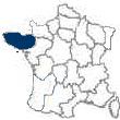
The Region of Brittany [Bretagne] is located on the peninsula, that extends about 150 miles into the Atlantic, in the extreme northwest of France, and separates the English Channel from the Bay of Biscay.
It is almost identical to the historic province of Bretagne, and consists of the départements of
Côtes-d’Armor [Côtes-du-Nord],
Finistère,
Ille-et-Vilaine and
Morbihan.
The old province also contained the Département of Loire-Atlantique, which is now a part of the Region of
Pays-de-la-Loire.
The region is bordered by the English Channel to the north,
Basse-Normandie [Lower Normandy] to the northeast, Pays-de-la-Loire [Western Loire] to the east, the Bay of Biscay to the south and the Atlantic Ocean to the west.
Its capital is
Rennes.
The History of Brittany
People probably lived in the region before 8000 BC.
The first known, but unidentified peoples, built the great prehistoric megalithic monuments, known as menhirs and dolmens, that still stand.
These were probably constructed between 3500 and 1800 BC, and are located near the town of Carnac and at other sites.
When the
Celts migrated here they, in all likelihood, intermingled with the prehistoric peoples, and built the region into a confederation of
Cymric Celtic tribes.
In 56 BC, Julius Caesar conquered the region for Rome.
This addition to the Roman Empire was known by two names: Armorica, a Romanization of the Celtic word for ‘seaside’, and ‘Gallia Lugdunensis.
The name of the Département of
Côtes-d’Armor is derived from the Romanized Celtic word.
Although the region’s name was easily Romanized, the region’s inhabitants were not.
They were probably the least Romanized of all of Gaul, especially when it came to the use of the Latin language.
The Romans withdrew from Armorica in the
5th century.
They were replaced, especially in the northwestern part of Armorica, over the course of the 5th and 6th centuries, by other Celts from Britain who were fleeing the Anglo-Saxon invaders.
During the next 300 years there was a literal ‘invasion’ of Celtic missionaries from the British Isles who came to Christianize the Celts of Brittany.
Thus, from the Celtic migration and the inundation of missionaries, the region became known as Bretagne, the French word for Britain, or Brittany.
The Celts that migrated there were known as ‘Bretons’, the French for ‘Britons’.
The people of Brittany have always felt apart from the French.
During the Middle Ages, when the French language was hardly spoken in most parts of Brittany, they fought to be an independent duchy.
Over the course of the 7th and 8th centuries Brittany spawned a number of principalities.
Early in the 9th century, these principalities became subjugated to
Charlemagne.
In the 846, they were united under their national hero Nomenoë who lead a revolt against the Charlemagne’s grandson, the Carolingian king
Charles the Bald, and won their independence.
Later, Nomenoë repelled the Norse invaders.
In the 10th century, his successors located the capital of their duchy at
Rennes.
In 922, Geoffrey, count of Rennes, became the duke of Brittany.
During this period, there was great conflict with the Norman dukes to the northeast.
The duchy of Brittany was annexed into the Angevin Empire in 1171.
This took place due to the marriage dowry received by Geoffrey Plantagenet, the son of Henry II, king of England.
Subsequently, the duchy fell under the control of the French
Capetian dynasty. In the 13th century, control of the duchy reverted to the French dukes who were located at Rennes.
During the later part of the Middle Ages, in the mid 14th century, a civil war broke out in Brittany between the supporters for a French heir and those for an English heir to Brittany.
The Montforts, who won out, tried to keep the region neutral for the remainder of
the Hundred Years’ War.
In 1491, when Anne of Brittany married the French king
Charles VIII, Brittany was temporarily united with France.
She subsequently married
Louis XII.
During the reign of
Francis I, who had married Anne’s daughter Claude, the union with France became formal.
The treaty of 1532 made Brittany a French province.
It also guaranteed local privileges to the region.
Over the course of the next two centuries, Brittany fought the crown’s attempts to centralize all power.
In the years of the French Revolution, Brittany was in opposition to the forced reorganization of the Roman Catholic Church.
In both the 19th and the 20th centuries, Brittany had been conservative in maintaining the old religious sentiments.
There is, even today, an ingrained separatist movement in the region.
And today, over a quarter of Brittany’s population speak Breton, a language that is closely related to the Celtic Cornish and Welsh.
The Universities of Brittany, in
Brest and
Rennes, are centers for Celtic studies.
The Geography of Brittany
Brittany’s coast is both rugged and indented, composed of rocky land in the north and sandy, sun swept beaches in the south.
The jagged, 750 mile long coastline, which is twice as long as it would be if it were not jagged, is doted with small and picturesque fishing villages.
Much of the coastline, especially at the western tip of Brittany, is characterized by cliffs, capes, islands, rocks and reefs and by ominous topographical names.
The coast is at its most beautiful at high tide, and the difference between high-tide and low-tide is among the world’s greatest – up to 49 feet at the Bay of Saint-Michel and 43 feet on the Bay of
Saint-Malo.
And, where the tides are the greatest, the distance between the high-tide mark and the low-tide mark can be the greatest – up to 12 miles at the Bay of Saint-Michel.
The visual effect of the incoming tides’ height and speed is awesome.
The waves can reach 100 feet in height and the sound is deafening.
Its shock can be felt up to 18 miles away.
The peninsula’s interior is set on the Argoat [country of the wood] plateau where small farm fields are surrounded by hedgerows.
This is a landscape known as bocage.
The region is known for its scenic villages and towns and its picturesque landscapes.
However, it is no longer a ‘country of wood’. Since Roman times, the once immense forests of beech and oak have been cut so that only scattered strips of trees are left.
These are mostly found near the banks of the rivers.
Brittany is characterized by a large number of small villages, several small towns, one city and no large urban areas.
Rennes, the capital, is the region’s only city.
Brest, which is located at the far western tip of the peninsula, is a French naval base.
Lorient, which is located along Brittany’s southern coast, is a major fishing port.
The Culture of Brittany
Brittany developed a unique culture due to its long isolation from the rest of France.
Until the first part of the 19th century, the vast majority of its inhabitants spoke Breton and their everyday dress consisted of distinct local costumes. This Breton culture can be seen today during church festivals and other events when the old costumes with their “coiffes” [hats of lace] – a different hat in each area – can be seen.
The differential between Brittany, and the rest of France, was reduced after the last half of the 19th century.
Today, most Bretons speak French and wear modern Western-style clothing, while only one-forth of the population can speak Breton.
Only a small fraction of the population still wears traditional costumes on a daily basis, and most of them are older women.
Traditional costumes are now only common on special occasions.
Catholicism has been a strong regional influence since the 4th and 5th centuries, with most Bretons being Roman Catholics.
Brittany has conserved its social structure most in the rural areas where families are large and under paternal authority and the nobility still has influence.
Most holidays are also church festivals and mark the foundation of the region’s religious and social life.
The BLF, the Breton Liberation Front, is an illegal organization to which only a small number of Bretons subscribe.
It advocates absolute independence for the region, and its members have carried out terrorist bombing with the object of calling attention to their cause.
However, the vast majority of Bretons advocate French rule, with the majority of those calling for more local control of their political affairs.
A common thread, between all groups, is dismay over the decline of the Breton culture and a desire to restore its importance.
The Language of Brittany
Breton is spoken principally in the Brittany départements of Cotes-d’Armor, Finestere and Morbihan.
It is a subclass of the Brythonic group of Celtic languages.
It is spoken in Brittany, having been introduced there by the Brythonic Celtic refugees that settled there after fleeing southern England in the 5th and 6th centuries.
Since the 17th century, the language has been subgrouped into the four major regional dialects of Cornouaille, Léon, Tréquier and Vannes.
All four are more closely related to the Welsh than to the Cornish Celtic language.
Breton has been greatly influenced by both the preexisting Celtic language of Brittany and by the French language.
The Cornish and Welsh versions of the language absorbed a vast number of English loan words during a time that Breton’s vocabulary was substantially increased by the French.
More recently, during the mid-20th century, two standardized forms of Breton were developed for the express purpose of encouraging the language’s literary development.
The French government has not been sympathetic to this goal and officially encourages the French language, which is mandatory in school.
Breton cannot be taught in primary and secondary schools.
It is consequentially not surprising that the number of speakers of Breton is decreasing. Today, very few children are being raised in the Breton language and the vast majority of Breton speakers are only literate in French.
The Economy of Brittany
Fishing, farming and tourism are the important sectors of Brittany’s economy.
Of the three, fishing is the mainstay.
Brittany accounts for both the greatest number of tones, and the greatest monetary value of the catch, about a third of France’s fishing catch.
Over the years, many farms have consolidated and, although they continue to raise fodder, many concentrate on animal husbandry.
Brittany is a leading producer of milk products.
Chickens and pigs are raised in feedlots to produce meat that is sent to the rest of France.
Due to a lack of energy and raw materials, its industries have remained relatively undeveloped, with the exception of space and telecommunications industries that have grown rapidly in the Département of
Cotes-d’Armor.
These industries have fueled the development of related industries in
Brest and
Rennes.
The Gastronomy of Brittany
- The Wine
- The Cheese
- The Cuisine
Brittany Département Information
|
Côtes-d'Armor [Côtes-du-Nord] [22]
Formerly known as Cotes-du-Nord, the Département of Cotes-d’Armor was created in 1790. It is the northern most département of the Region of
Brittany. It is bounded by the English Channel to its north, and the Départements of
Ille-et-Vilaine to the east,
Morbihan to the south and
Finistère to the west. Cotes-d’Armor has four arrondissements: Dinan, Guingamp, Lannion and Saint-Brieuc.
Saint-Brieuc is the département’s capital.
Cotes-d’Armor’s picturesque Émeraude Coast, that looks north to the Channel, is a see-sawed, indented barrier against the sea that is dotted by charming seaside resorts and old fishing villages. Most of the towns of the interior were founded in the Middle Ages. The département’s southern half is crossed by the Noires Mountains that run west to east and constitute the watershed divide between northward flowing rivers, that empty into the Channel, and the rivers emptying to the south into the Bay of Biscay.
Horses and cattle are pastured on the interior plateaux that are swept by the strong west to east winds that drive the heavy Atlantic rain bearing winds. Along the coast, fishing was once important but is now secondary to the cultivation of fruit, oats, potatoes and wheat. Cattle and pigs are also produced there. Building stone and slate are quarried and there is some boating building and tanning.
Finistère [29]
The Département of Finistere was carved out of the far western part of the historical province of Brittany, and as such is the most western of all French départements. The name Finistere comes from the Latin phrase ‘finis terrae’, meaning ‘land’s end’. It is bounded by the English Channel to the north, by the Départements of
Cotes-d’Armor [Cotes-du-Nord] and
Morbihan to the east, by the Bay of Biscay to the south and by the Atlantic Ocean to the west.
The east-west oriented Montagnes Noires, which rise to the height of 1001 feet in the region’s north, are separated from the parallelly oriented, 1260 foot high Montagnes d’Arrée, in the south, by the Aulne Basin. Both ranges are composed principally of granite.
Quimper, the départemental capital, is located to the south. It has a distinctive Breton character and is a tourism center. The Département of Finistère has four arrondissements:
Brest, Châteaulin, Morlaix and Quimper.
Agricultural production is particularly favored in the département’s northeast, with cattle, cereals, fruits and vegetables being produced. Over a third of the département is covered with forests, moors and wasteland. Along the coast, farmers divide their time between commercial fishing and the working of their small farms. France’s second-leading fishing port is Douarnenez. Brest, on the western coast, is a leading naval port. The region has limited industrial production which includes agricultural machinery, foundries, engineering works and naval and riverboat shipbuilding.
Ille-et-Vilaine [35]
The Département of Ille-et-Vilaine was created from the northeastern part of the old province of Bretagne. The département is generally flat and there are forests, dunes and marshes in the north. It is bounded by the English Channel and the Region of
Basse-Normandie [Lower Normandy] to the north, the Region of
Pays de la Loire [Western Loire] to the east and south and the Départements of
Morbihan and
Côtes-d’Armor [Côtes-du-Nord] to the west. Ille-et-Vilaine’s coastline stretches westward from 3 miles west of
Mont-Saint-Michel to an estuary 5 miles west of Dinard. Ille-et-Vilaine’s costline includes part of the rocky Côte d’Émeraude and the Rance River estuary where the towns of
Saint-Malo and Dinard are located.
Rennes, the départemental capital, is located in approximately the center of the département. It is situated on the Ille et Rance Canal which connects the north flowing Rance River with the Vilaine River that flows southwesterly into the Atlantic. The University of Rennes was founded in 1735. It is known for its Department of Breton Culture and Celtic languages. Ille-et-Vilaine is divided into four arrondissements:
Fougères, Redon, Rennes and Saint-Malo.
There is a 25 foot differential between the low tide and the high tide at the Rance River estuary, making it ideal for the generation of tidal electricity. To the east, the coastal strip of the bay of Mont-Saint-Michel is used for market gardening and sheep raising. Oysters are cultivated along the coast near Cancale. As the fishing industry has declined, coastal resorts have become more important to the economy. Wheat, fodder crops and vegetables are raised in the fertile Rennes basin and the département engages in apple growing for cider making. Rennes has become industrialized in more recent years and a women’s footwear industry has grown up at Fougères.
Morbihan [56]
The Département of Morbihan was created from the southeastern part of the historic province of Brittany. The département takes its name from the virtually landlocked Morbihan Gulf, on the south coast, where the ancient town of Vannes is located on estuaries opening onto the gulf. Morbihan is bordered by the Département of
Côtes-d’Armor [Côtes-du-Nord] to the north,
Ille-et-Vilaine to the east, the Region of
Pays de la Loire [Western Loire] to the southeast, the Bay of Biscay to the south and the Département of
Finistère to the west.
The Montagnes Noires, rising only to 970 feet, form practically the length of the département’s northwestern boundary. The central plateau of the Landes de Lanvaux runs virtually the length of the département, parallel to the cost. In the east, the main streams flow eastward into the Vilaine River. In the west, rivers such as the Scorff and the Blavet, flow southward to the ocean. The entire Morbihan coast is jagged. To the west of the Gulf of Morbihan is the Quiberon Peninsula that juts out into the Bay of Biscay, and to its south is the island of Belle-Île-en-Mer.
Morbihan’s principal economic activities are agriculture, fishing and tourism. Oysters are cultivated in the Gulf of Morbihan. At
Lorient, a naval port on the estuary of the Leita River, submarines are built. Tourism is popular along the entire Morbihan coast and among the medieval towns and villages. The département has, just in the Carnac-Locmariaquer area, west of the Morbihan Gulf, literally thousands of prehistoric megaliths and the département boasts of having more prehistoric stone monuments than any other French département. Carnac has stones laid in concentric circles built by ancient peoples. These megaliths and dolmens and menhirs are believed to have been placed there between 3500 and 1800 B.C.
Vannes has some light industries and the harbor towns of Étel, Port-Louis, Groix and Quiberon have small canning factories.
Morbihan is divided into the arrondissements of Lorient, Pontivy and Vannes. The département’s capital is Vannes.
|
|
|
|
Brittany Town Information
The
Major Cities/Towns of Brittany
|
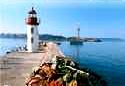
Brest
Brest is a seaport, with an excellent protected harbor, located at the far northwest extremity of Brittany where the Penfeld River meets the Bay of Brest in the Département of
Finistere. It is France’s premiere naval facility, boasting a rich maritime history. The river divides the city by flowing between the two opposite hills upon which the city is perched. The river is crossed by the Pont de Recouvrance, Europe’s largest lifting bridge. Brest is situated on Route National 12, 246 miles southwest of Cherbourg, 132 miles west-northwest of
Rennes and 351 miles west of
Paris.
The city dates from the Roman times when a settlement was established around 50 B.C. The Château, which was constructed from the 12th century to the 17th century, is now a naval museum. In 1240, Count Hervé V ceded Brest to John I, duke of Brittany. From 1342 until 1397, the English occupied the town. Brest passed, through marriage, from Brittany to the French crown in 1491. In 1631, Cardinal Richelieu hastened the city’s development when he had the natural harbor improved for the major naval base he established there. In the 1680’s, Jean-Baptiste Colbert improved the harbor and Sébastien Le Prestre de Vauban,
the well known French military engineer, fortified
it. Colbert also initiated the Maritime
Inscription of 18 to 48 year old Breton fishermen
into the naval reserve. This system is still
operative.
In 1694, the fortified harbor withstood an attack by combined Dutch and English naval forces. In the 18th century, Brest was the main base for France’s Atlantic Fleet. In 1830, the French Naval Academy was established at Brest. Subsequently, a university was founded.
During World War I the harbor facility was used for the debarkation of American troops and as their supply base. Between the wars, Brest’s importance as a transatlantic passenger port and as a naval base increased. The Germans occupied Brest between 1940 and 1944, during World War II, and build concrete underground submarine pens for their Atlantic Wolf Packs. Allied bombing razed the base and most of the city including the old town.
Following the war, the port and naval base were restored and re-equipped. The city has been rebuilt by laying out the streets and avenues in a rectangular fashion. The wide Rue de Siam runs from the Pont de Recouvrance to the enormous Place de la Liberté. Today, Brest and
Toulon are the major French naval bases. Brest is the Headquarters for the French nuclear submarine fleet.
Naval construction, repair and shipping have long
been important to Brest’s economy, with the port
being the city’s major employer. During the
1960’s, industrial zones were created to counter a
decline in naval activity. Today, the economy
engages in the manufacturing of chemicals, clothing,
electrical equipment, fertilizers, machinery, paper
and textiles. Other industries include gas
bottling, precision mechanics, ship building and
processed food.
Océanopolis, which is located by the Port de Plaisance, provides a hands-on sea encounter with aquariums, exhibits and seals.
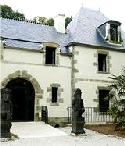
Fougères
Fougères is a medieval fortified town located in a picturesque setting on a hill over looking the winding Nançon River. It is located in the northeast portion of Brittany near the
Basse-Normandie border. It is situated on Route National 12, 25 miles northeast of
Rennes in the Département of
Ille-et-Vilaine.
During the medieval period the town was militarily important. In 1166, Fougères’ 12th through 15th century castle was completely destroyed by King Henry II of England, but was immediately rebuilt. Over subsequent centuries, the town and castle changed hands a number of times and was partially destroyed. Today, the castle remains remarkably intact; the13 original towers and the10 foot thick walls still remain. These walls are considered to be the most massive in Europe.
The town has two churches, the 16th century Eglise Saint-Léonard, which is off the Place aux Arbres, behing the Château. The Eglise St-Sulpice is in the Flamboyant Gothic style, with an 18th century wood-paneled interior. There are a number of picturesque old houses, located along the river, just off the Place du Marchix, dating from the 15th to the 17th century. The town has often appeared in French literature, having been host to such writers as Gustave Flaubert and Victor Hugo.
In the 13th century the manufacture of sail cloth was begun in Fougères. The town subsequently furnished sails for the French navy until the advent of steam powered ships. In 1832 the town made its first woolen slippers. This was followed, in 1852, by the manufacturing of leather shoes by hand at home. By the end of World War I there were some 80 shoe factories in production. The remaining shoe factories now manufacture mostly women’s shoes. Today, Fougères also produces precision machinery.
Lorient
Lorient is located on the right bank of the Scorff River at its juncture with the Blavet River at the Bay of Biscay. It is in the Département of
Morbihan, at the intersection of Route National 165 and D 769, 34 miles southeast of
Quimper, 31 miles west-northwest of
Vannes, 88 miles west-southwest of
Rennes and 183 miles west-southwest of
Paris.
Lorient began as the medieval village of Blavet. During the reign of
Louis XIII, 1610 to 1643, the king built a citadel at Blavet and the site was renamed Port-Louis. In 1664, during the reign of
Louis XIV, Colbert chartered a merchant trading company to settle there and trade with the far east. The site was then renamed ‘L’Orient’ because of its trade with the East. As the town grew, a second trading company settled there in 1719.
Following France’s loss of its Indian possessions, commercial activity in Lorient declined. During the reign of
Louis XVI, 1774 to 1792, the crown established a royal arsenal there. In the period of the
Empire, Lorient became a naval base. Today, its arsenal specializes in the construction of prefabricated naval ships. From June 25, 1940 to May 8, 1945, when Free French forces liberated the town, Lorient had been occupied by the Germans who had built a submarine base. The base is now used for French submarines.
Lorient is really the site of 5 ports: a military port [with 30 submarine pens and dockyards]; the Kergroise commercial port, specializing in importing animal foodstuffs; the Kéroman fishing port [the only French port designed and equipped for commercial fishing]; the Kernevel pleasure boat harbor and a passenger port. The town and ports were destroyed during World War II and were completely rebuilt after the war.
The town’s main industries consist of fish processing and canning, furniture, pleasure craft navigational equipment, paint, ship building and textiles. The Kéroman port sends seafood to both
Bordeaux and
Paris by rail.
Quimper
Quimper, the capital of the Département of
Finistere, is situated in a pretty valley at the confluence of the Odet and Steir river estuaries, in the southwestern corner of Brittany. It is the ancient capital of La Cornouaille, Brittany’s most traditional region, and has a distinctive Breton character. It is at the intersection of Route National 165, D785, D765 and D783, 34 miles northwest of
Lorient, 111 miles west of
Rennes and 303 miles west-southwest of
Paris.
Quimper was originally settled during Roman times. Its name was derived from the Breton word ‘Kemper’, meaning the confluence of two rivers. By AD 495, the town had become a Bishopric. It subsequently became the capital of the counts of Cornouailles. In the 11th century, it was united with the Duchy of Brittany. During the civil wars, of the 14th century, the town suffered considerable ruin. In 1364, the duchy passed to the House of Montfort.
The town has a rustic atmosphere with charming footbridges spanning the rivers that flow through it. The Church of Locmaria, a Romanesque structure, dates from the 11th century. The Cathedral of Saint-Corentin, with its magnificent Gothic-style façade, was constructed between the 13th and 16th centuries. It is the oldest Gothic structure in Lower Brittany. Its two towers are 250 feet tall; its spires were added in the 19th century. The 15th century stained glass windows are exceptional. The cathedral was named after Quimper’s first bishop.
To the cathedral’s west are the pedestrianized streets of Vieux Quimper with a wide array of crêperies, half-timbered houses and shops. Near the Episcopal palace, which now holds the Musée départemental Breton [devoted to regional history, archaeology, ethnology and economy] are the ruins of the town’s 15th century walls. Nearby is the Musée des Beaux-Arts. The museum has a 19th century façade and an entirely rebuilt interior. It houses a collection of 14th to 21st century paintings that includes works by Boucher, Corot, Oudry and Rubens along with canvases by such Pont-Aven school painters as Bernard, Denis, Lacombe, Maufra and Sérusier.
The town’s best known product is Quimper Faïence Pottery. It has been made here, since 1690, using bold provincial designs of Jean-Baptiste Bousquet. The town’s eating establishments boast of some of the best crêpes and cider in Brittany. The town has also been known for copper and bronze work, food items, galvanized ironware, hosiery, leather, paper and woolen goods.
Rennes
Rennes, the capital of the Département of
Ille-et-Vilaine, has long been a regional center, rich in historical monuments and customs, and a major Brittany intellectual and industrial city. It is located at the confluence of the Ille and the Vilaine rivers, almost in the center of the département. The city is located 111 miles east of
Quimper, 88 miles east-northeast of
Lorient, 25 miles southwest of
Fougères, 132 miles east-southeast of
Brest and 190 miles west-southwest of
Paris. It is situated at the juncture of Routes Nationals N 24, N 12, N 137, N 157 and D 175, D 463, D 163 and D 177.
Rennes’ name is derived from the name of a Celtic tribe, the Redones, who founded their capital at this site in pre-Roman times. During the Roman period, Rennes served the province of Armorica as its transportation center. In 1532, Brittany became a part of France. Subsequently, in 1561, the Parliament of Brittany was established in Rennes, making it the seat of the duchy of Brittany. Ultimately, the Parliament of Brittany was one of the 13 provincial parliaments making up the kingdom of France.
In 1720, the town was badly damaged by a fire lasting 6 days. It was rebuilt with wide avenues and canals radiating from the city’s central hub, running in parallel with the canalized Vilaine River. During the French Revolution, the Republican Army established its headquarters here for its fight against the Vendées royalists. The city was badly damaged by bombing in World War II.
The Old Town [Vieux Rennes] is the part of Rennes that escaped the 1720 fire. The Vieux Rennes is mostly pedestrianized and is a center for bars, crêperies and boutiques. The Rue de la Monnaie, at the western edge of the Old Town, begins at the remaining 15th century city gate, the Portes Mordelaises.
Vieux Rennes is also the site for the Cathedral. Here, the two towers of the Cathédral Saint-Pierre, which was finished after 57 years of work, in the first half of the 19th century, were part of an earlier church that was partially destroyed by the 1720 fire. The cathedral is the third church to stand on this site. The stucco facing of the interior is covered with gilding and paintings. The 16th century Flemish gilded and carved wood altarpiece, in the chapel by the south transept, is a masterpiece.
Only a few buildings, on the north side of the Vilaine, survived the fire. Among the surviving structures is the Palais de Justice, which is Brittany’s Parliament. The typical
Louis XV style town hall was designed and built by Jacques Gabriel during the 18th century. A number of half-timbered private mansions with carved sills, that escaped the great fire, line the streets in the vicinity of the Place du Palais and the Place de l’Hôtel de Ville. To the northeast are the French classical gardens of the Jardin du Thabor that was originally a part of the 16th century Benedictine Abbey of Sainte-Mélaine. The abbey’s lands were transformed, in the 19th century, into these gardens of varied flowers, trees, botanical garden and aviary.
To the southeast of the Place de l’Hôtel de Ville is the building that houses both the Musée de Bretagne and the Musée des Beaux Arts. The Musée de Bretagne presents displays that provide an excellent insight into Brittany’s history. The Musée de Bretagne displays a collection of 14th through 21st century art.
Rennes has long been the seat of an archbishopric. The Universitie of Rennes was founded in 1735 and was reorganized into Rennes I and II in 1970. The university complex includes a medical school and several other specialized schools. The university is well known for its Celtic studies.
Rennes was traditionally an important market town. Since World War II, it has become industrially important for such products as automobiles, agricultural machinery, chemicals electronics, printing, processed food, railway equipment and textiles. Nearby, in Vern-sur-Seiche, is a petroleum refinery. The city is an important rail and road junction connecting
Paris with Brittany.
Saint-Brieuc
Saint-Brieuc is situated on a plateau between the Gouëdic River and the canalized Gouët River on the north coast of Brittany. It is located barely 2 miles from Saint-Brieuc Bay on the English Channel. The town sits astride Route National N 12, at its intersection with D 700. It is 80 miles east of
Brest, 48 miles southwest of
Saint-Malo, 57 miles northwest of
Rennes and 235 miles west of
Paris. It is the capital of the Département of
Côtes-d’Armor [Côtes-du-Nord].
Saint-Brieuc was named after the 5th century Welsh monk, St. Briocus, who evangelized the area. The town grew up about the monastery he established. During
the Hundred Years’ War, 1337 to 1453, the English besieged the town. In 1375, Olivier de Clisson defended the town against the duke of Brittany. But, in 1394, Clisson himself attacked the town. In 1592, during the Wars of Religion, the Spaniards pillaged the town. It was struck by the plague in 1601.
The Cathédral de Saint-Étienne was constructed over the course of two hundred years, from the 13th to the 15th century, as a church fortress. The seven bays of the lofty nave were rebuilt in the 18th century. The wooden altar, in the south aisle, was carved by Corlay around 1745. The southern transept is lighted by beautiful 15th century stained glass windows. The cathedral was restored in the 19th century. To its north are many 15th and 16th century half-timbered and corbelled houses.
Saint-Brieuc is an important northern Brittany market town and tourism center. Its port is engaged in outfitting vessels for the Newfoundland and Iceland fishing fleets. The town’s products include brushes and metallurgy. A national school of navigation is located in the town.
Saint-Malo
The seaport of Saint-Malo is situated on the right bank of the estuary of the Rance River in the Département of
Ille-et-Vilaine. Part of the town is constructed on a rocky promontory. It is connected to the old walled city, on a nearby granite islet, accessed by an old causeway. The town is located at the juncture of Route National N 137 and D 156, 40 miles north-northwest of
Rennes, 48 miles northeast of
Saint-Brieuc, 36 miles west of le
Mont-Saint-Michel and 240 miles west of
Paris.
Saint-Malo was named for a Welsh monk, Maclou, who fled to nearby Saint-Servan, during the 6th century, where he built a monastery. It wasn’t until the 8th century that the Saint-Malo islet was substantially populated by those from the surrounding areas seeking refuge from the Normans.
Saint-Malo was fortified with ramparts during the period from the 12th century to the 18th century. In 1144, the bishopric was transferred to the islet from nearby Saint-Servan, where it remained until abolished in 1790. During the 14th through 17th centuries the town’s bishops oversaw the construction of a large fortress.
Saint-Malo prospered during the 17th and 18th centuries as a result of its navigators, privateers and traders. During World War II, three-fourths of the town was destroyed. Following the war, the town was scrupulously restored to its prewar charm.
The Cathédral of Saint-Vincent was begun in the 11th century and finished in the 18th century. Its west façade is in the Renaissance style. The cathedral’s somber 12th century nave is roofed with Angevin styled quadripartite vaulting. This contrasts the slender 13th century chancel’s radiant lighting provided by its modern stained glass windows.
The town of Saint-Servan, to the south, merged with the seaside town of Parmé, to the east, and with Rothéneuf and Saint-Malo to become the municipality of Saint-Malo in 1967. Today, the Saint-Malo port has more than 2.5 miles of docks and trades mostly with England and Scandinavia. Its harbor has specialized facilities to accommodate a fleet of trawlers as well as yachts and pleasure craft. There is regular summer ferry service from the harbor to the Channel Islands of Jersey and Guernesey and there is daily car ferry service between the harbor and Portsmouth England.
Saint-Malo, in addition to being a fishing port and a commercial seaport, has become a manufacturing center for such products as boats, lace and processed food. The port’s imports consist of fertilizers, timber and wood. Because of the town’s uniqueness, it has become one of the most popular tourist attractions in Brittany.
Vannes
The historic town of Vannes is configured in the shape of an amphitheatre, just a mile inland from the virtually landlocked Gulf of Morbihan, at the confluence of the two streams that form the Vanne River. It is the capital of the Département of
Morbihan. The town is located at the juncture of Routes Nationals N 165, N 166 and D 767, 95 miles southeast of
Brest, 67 miles northwest of Nantes, 57 miles southwest of
Rennes and 339 miles west-southwest of
Paris.
Vannes, originally known as Darioritum, was the ancient capital of the Veneti, a seafaring Celtic people whom the Romans conquered in 56 BC. Later, the Veneti lead an unsuccessful uprising against Julius Caesar. In 466, Saint-Paternus, the Celtic ecclesiastic, was consecrated the first bishop of Vannes. For a period, Vannes was ruled by a series of independent counts and was subsequently dominated by the Franks. In 845, the Breton leader of Armorica, Nominoë, defeated
Charles the Bald, and his Franks. He then founded the independent duchy of Brittany, with Vannes as his capital. In 1532, the duchy united with the French crown and the capital was transferred to Rennes.
Vannes has grown well beyond the old walled town that was perched upon a hill. Its ramparts, linked to gates and towers, were built from the 13th through the 17th century. They are well preserved on the eastern side of the town. The picturesque old city is enclosed by the ramparts and is grouped about its cathedral. The Cathédral de Saint-Pierre was burned in the 10th century. It was rebuilt during the 13th to the 19th century and its Chapel of the Holy Sacrament contains the tomb of the Spanish monk, Saint-Vincent-Ferrer, who died in Vannes in 1419. The Rue de la Monnaie, which runs south from the cathedral, is populated by well-preserved 16th century houses. To the cathedral’s northwest is the picturesque Place Henri IV which is lined with 16th century gabled houses.
The archaeological museum, the Musée d’Archéologie du Morbihan, occupies 3 floors in the 15th century Château Gaillard which once contained the Parlement de Bretagne. It holds an impressive collection of prehistoric items such as jewelry, polished axes, pottery and swards. It also houses medieval and Renaissance art objects.
The Aquarium océanographique et tropical contains thousands of fish from all over the world. There is even a live coral reef populated with numerous species of colorful fish. There are also sharks and a large sawfish.
Vannes is a prominent agricultural center for poultry farming and for the preparation of cattle and poultry foodstuffs. Its industries include fabrics, leather, metalworking, the production of prefabricated building materials and tires. The town’s flower gardens are a popular tourist attraction.
|
|
|
|
|