Bar-le-Duc
The quaint old town of Bar-le-Duc is the capital of the Meuse Département. It is built on a limestone plateau along the narrow Ornain River [a tributary of the Marne River] Valley near the Canal-de-la-Marne-au-Rhin that also flows through the valley. The town is located at the intersection of Routes National 35 and 135, 125 miles east of
Paris and 43 miles west-northwest of
Nancy.
Bar became the seat of a countship in the 10th century and subsequently became a duchy. In 1301, the Capetian king,
Philippe le Bel, persuaded the Count de Bar to accept him as his sovereign. In 1484 the countship was absorbed into the Duchy of Lorraine. Latter, in 1766, it became a part of France.
The town of Bar-le-Duc is divided into the Ville-Haute [Upper Town] and the Ville-Basse [Lower Town]. The Upper Town is on the high ground to the southwest of the Ornain River and the Lower Town, industrial in character, is between the Ornain and the canal.
The construction of the Church of Saint-Étienne, in the Upper Town, began in the 15th century. The church was mostly completed in the 16th century. Its medieval style belfry was added in the late 18th century. The church contains two paintings by the 16th century master Ligier Richier.
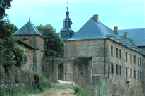
There are a number of 15th, 16th and 17th century houses that still remain in the area of the Place Saint-Pierre. The Upper Town also contains the remains of the counts’ 6th century Rhenish Renaissance château.
The Lower Town is the site of the 15th century Church of Notre-Dame and the buildings of the municipal offices.
The area surrounding Bar-le-Duc is enclosed by hills planted with vines and by wooded areas.
An industrial zone was set up, near the town, in 1960. There is now some food processing, heavy industry, metalworking and textile manufacturing. Bar is noted for its currant jam.
Épinal
Épinal is located along the Moselle River and at the crossing of Routes National 57 and 420 and D46. It is 36 miles south-southeast of
Nancy and 38 miles west of
Colmar. Épinal is the capital of the Département of Vosges.
The town of Épinal grew up around the 10th century monastery founded by the Bishop of
Metz. The bishops of Metz ruled the town until the populist revolt of 1444. In their rejection of the clergy, the people
affiliated themselves with
Charles VII. In 1466, his successor,
Louis XI of France, refused to protect the town and it fell into the hands of the Duke of Lorraine, René II. In 1766, Épinal was annexed by France.
During the
Franco-Prussian War of 1870, Épinal was briefly occupied by the Germans. Subsequently, it was heavily fortified and integrated into the system of fortifications that frustrated the Germans during World War I. Following the Great War, it was integrated into the Maginot Line.
In the Second World War, the Germans skirted the formidable defenses of the Maginot Line by pivoting north through the Ardennes and the Low Countries in 1940. Épinal was held by the Germans until late 1944.
Épinal is divided into four sections by two arms of the Moselle River: The main town is on the east bank of the main chanel. It is called both the Grande-Ville and the Vieille-Ville. On the west bank, of the smaller branch, known as the Canal des Grands Moulins, is the Quartier de la Gare. It is divided from the Quartier de Chantraine, to the far west of the town, by the railroad tracks. The Petite-Ville is located between the river’s two chanels, on an island.
The remains of an old château-fort still stand in the Parc du Château. The old fortress, which was destroyed in 1670, is on a height overlooking the Grande- Ville from the east.
The provincial charm of the Place des Vosges, with its preserved ancient arcades and older houses, is found in the Grande-Ville. The Basilica of Saint-Maurice, which is also located in the Grande-Ville, is nearby. Its tower was begun in the 13th century. The Church of Notre-Dame is in the Quartier de la Gare and the Musée d’Art Ancien et Contemporain is at the southern foot of the Petite-Ville.
Épinal was, during the 18th century, one of France’s ceramic centers. Following 1871, as a result of heavy immigration from German held Alsace-Lorraine, many textile mills were located here. Since 1969, Michelin has been manufacturing wire threads for its radial tires to the north of the town.
Lunéville
The town of Lunéville is located at the confluence of the Meurthe and Vezouze rivers in the département of Meurth-et-Moselle. It lies just north of the intersection of Routes National 4 and 59, 14 miles east-southeast of
Nancy, 55 miles west-southwest of
Strasbourg and 33 miles north of
Épinal.
During the 15th century, Lunéville became a part of the duchy of
Lorraine. In 1766, the town was annexed by France. On February 9, 1801, after several defeats at the hands of
Napoléon, Austria was forced to sign the Treaty of Lunéville with France. Under the terms of the treaty, Austria recognized the natural boundaries of France as being those established by
Julius Caesar for Gaul. These boundaries were the Rhine River and the Alps to the east and the Pyrénées to the south.
In the medieval period, Lunéville was a walled town. In the 18th century the town was planned with wide streets and a great park. It has a Rococo style church and a château that was inspired by Versailles. The château, a virtual replica of
Louis XIV’s Versailles, was built by the duc de Lorraine, Léopold, as his residence. The château has a museum.
The town’s chief products are faience fine porcelain, railroad equipment and textiles. The faience fine is a tin-glazed earthenware, often times with a Japanese-like or a whimsical decoration. It has been produced at Lunéville since 1723.
Metz
The appealing but austere city of Metz is the capital of the Moselle Département and of the
Region of Lorraine. It is located in the northern part of Lorraine near Germany and Luxembourg, near the confluence of the Moselle and Seille rivers.
Metz, a rail junction on the
Nancy-Luxembourg line, is the center of a complex road network. It is located at the intersection of Route National 3 and the Autoroute A31, just south of the Autoroute A4. The town is 31 miles east of
Verdun, 27 miles north of
Nancy and 25 miles west of the German Border.
Metz was the capital of a Gallic tribe named the Mediomatrici, and derives it name from the tribe. From the 1st century BC until the 5th century AD, the Romans used it as a military post. In the 3rd century the town was Christanized and became a bishopric in the 4th century. The town was fortified, during the 4th century, as a response to the ominous Germanic tribes to the east.
Metz was plundered by the Huns in the 5th century. The Franks took the town in the same century and made it the capital of the Austrasia kingdom in the 6th century. Metz remained a part of the
Carolingian Empire until the 843 when the empire was divided among the three grandsons of
Charlemagne. It then became the capital of Lotharingia.
In the 12th century, Metz became a prosperous, free city within the Holy Roman Empire. During the Reformation it became a stronghold of Protestantism and requested the protection of France. In 1552,
Henry II of France, although a Catholic, offered to protect the town. He annexed Metz and Emperor Charles V laid siege to the city. The town was successfully defended, from October 1552 to January 1553 by François de Lorraine, the 2nd duc de Guise.
In 1648, the Holy Roman Empire ceded Metz, along with
Toul and
Verdun [the territory of the Trois-Évêchés - the three Imperial Bishoprics], to France under the terms of the Peace of Westphalia. Metz was subsequently heavily fortified.
In 1870, after a siege lasting two months, French marshal François Bazaine surrendered Metz to the
Prussians. The Treaty of Frankfurt, signed on May 10, 1871, ceded Metz, part of Lorraine and most of Alsace to Germany. It also required France to pay Germany 1 billion dollars.
Metz was returned to France under the terms of the Peace of Versailles that formally ended World War I. It was occupied again by the Germans in 1940 and was liberated by the Allies late in 1944 after a long battle.
Both world wars caused extensive damage to Metz. The city has been extensively rebuilt. After World War II its suburbs were greatly expanded.
The city has a number of points of interest. The Gothic Cathedral of Saint-Étienne is perched upon a hill overlooking the Moselle. It was mainly constructed during the 13th through 16 centuries. It’s interior is lighted by Gothic and modern stained glass windows, including one by Marc Chagall.
The Basilica of Saint-Pierre-aux-Nonnains [Saint Peter of the Novitiates] was built in the 4th century. Not far away is the Chapelle des Templiers. It was built during the 13th century by the Knights Templar.
The city has over 20 bridges crisscrossing the river and its canals. The Porte des Allemands, to the southeast of the cathedral, is a fortified bridge that spans the Seille River. Because of its defensive towers it resembles a medieval castle. It was constructed from the 13th to the 15th century. Nearby, there are pleasant promenades that have been laid out along the banks of both the Moselle and Seille rivers.
Metz is positioned near the Moselle coal mines and near the Lorraine iron-mining basin. The city produces automobiles, cement, electrical equipment, food products, leather goods, mechanical equipment, metal goods, textiles and tobacco products.
The
University of Metz was established in 1971.
Nancy
Nancy was the capital of the historic duchy of
Lorraine and is now the capital of the département of Meurthe-et-Moselle. It lies on the left bank of the Meurth River at its juncture with the Marne-Rhine Canal. It is on the low-lying land between the two rivers, just north of the Meurth’s junction with the Moselle. Its location is at the crossroads of Routes National 75 and 57, just north of Autoroute A33. Nancy is 30 miles south of
Metz, 90 miles west of
Strasbourg and 233 miles east of
Paris.
In the 11th century the small township of Nancy was dominated by a château. In the 12th century, when it became the capital of the dukes of Lorraine, the township was fortified. In 1477, while trying to capture the township, the
duke of Burgundy, Charles the Bold, was defeated and killed by forces from the Swiss Confederacy.
A new, and separate township, the Ville-Neuve, was founded in the 16th century. It was located nearby, to the south, by Charles III, duke of Lorraine.
The French captured the Ville-Neuve in 1633. After the Treaty of Rijswiik, in 1697, the township was returned to the dukes of Lorraine. In 1735, the duchy of Lorraine, and the town of Nancy, were granted to the ex-king of Poland who lost his throne in the War of the Polish Succession.
The city of Nancy is really the result of the blending together of the two old fortified towns. The medieval town to the north, the Ville-Vieille, was combined with the 16th century town to the south, the Ville-Neuve. To bring about the expanded town, Stanislaw Leszczvnski, the duke of Lorraine, had the walls that separated the Ville-Vieille from the Ville-Neuve torn down in 1750. At Stanislaw’s death, in 1766, the city reverted to France.
The city has a 16th century Gothic style ducal palace, with Flamboyant balconies that houses a museum, and the 15th century Church of the Cordeliers, with its round chapel, where several dukes are entombed. But its center piece is the 18th century town square and city center, the Place Stanislas, which has been designated by UNESCO as a World Heritage Site. The square is the focal center for a fine-arts museum, hotels, a theater, a triumphal arch, honoring
Louis XV, and a most imposing town hall. The Place Stanislas is located between the Ville-Vieille and the Ville-Neuve.
The duke of Lorraine, the former king of Poland and the father-in-law of Louis XV, commissioned the architect, Emmanuel Héré de Corny, to design the 400 by 350 foot square and its buildings. The metal worker, Jean Lamour, designed and built the square’s graceful gilded wrought iron gates and railings that stand at each corner and around the fountains of Neptune and Amphitrite. The result was to transform Nancy into one of Europe’s most palatial cities and to provide an almost perfect example of 18th century French architecture.
During, and after, the
Franco-Prussian War, French-speaking emigrants from
Alsace flooded into Nancy. In World War I, Nancy suffered considerable damage. From 1940 to 1945 the city was under the German occupation, but was left relatively unscathed.
Nancy is a départemental administrative center and a regional financial capital. Its
university, which was founded in 1572, was closed during the Revolution and was reopened in the first part of the 19th century. The University was reorganized in 1970. It is France’s third largest scientific university. The city also has a forestry and mining school.
The city is located in the center of an iron rich area. It is Lorraine’s commercial center, producing beer, boilers, catering equipment, chemicals, clothing, electrical equipment, furniture, glassware, printed material, processed foods, Textiles, tobacco and yeast.
Remiremont
Toul
Toul is a town in the département of Meurthe-et-Moselle. It is located on the left bank of the Moselle River at its juncture with the Marne-au-Rhin Canal. It is 12 miles west of Nancy, 31 miles south-southwest of Metz and 156 miles east of Paris, at the crossroads of D400 and Route National 411, just north of the intersection of the Autoroute A31 and Route National 4.
The town was originally the capital of the Leuci tribe of the Belgic Confederation. Under the Romans the town became somewhat important. By the 4th century Toul had been Christianized.
From the 10th century, the counts of Toul were its bishops who endeavored to link the town with nearby
Metz and
Verdun to form the territory of the Trois-Évêchés [the three Imperial Bishoprics].
Henri II annexed the Imperial Bishoprics in 1552.
Toul sought French protection in 1545. It subsequently became a part of France in 1648 as the result of the Peace of Westphalia. In 1700, the French military engineer Sébastien le Prestre de Vauban rebuilt Toul’s medieval fortifications. The French Revolution put an end to the town’s bishopric and Toul became a garrison town for the French army.
The town was taken by the Germans during the
Franco-Prussian War of 1870-71. After it was returned to France, during the early days of the
Third Republic, its fortifications were strengthened as part of the defensive system of forts designed to protect the strategic Toul Gap. Toul was again threatened by the Germans in 1914 and was occupied by them from 1940 to 1944.
The town was rebuilt after World War II. The 13th century Cathedral of Saint-Étienne, managed to avoid serious damage during the war. The cathedral had taken over 300 years to build and had been greatly influenced by the Early Gothic architecture in nearby Champagne. The neighboring 13th through 14th century Church of Saint-Genoult, with its Gothic façade flanked by towers with stained-glass windows, also survived the ravages of war as did the Renaissance houses that back-up to the church.
Toul is known for its porcelain and for its local ‘gray’ Côtes de Toul wines.
Verdun
The deeply trenched Meuse River Valley takes the river through the center of the ancient fortress city of Verdun which is located in the middle of the Meuse Département. There are two identifiable sectors of Verdun. The older part sits on a hill that rises, in stages, from the east bank of the Meuse. It is known as the Heights [Ville-Haute]. The newer section of town is located on the river’s left bank, near the Citadel. This section has residential, office and public buildings. Pedestrians reach the Heights by narrow stairs that run from the main street.
Verdun is situated at the juncture of Route National 3, D903 and D964, just north of the east-west Autoroute A4. It is 31 miles west of
Metz, 57 miles east of
Reims and 162 miles east of
Paris.
Prior to the area’s conquest by the Roman Empire, Verdun was important as a Gallic military stronghold and as a commercial center. One of the oldest towns in France, the Romans called it Verodunum. In 450 AD, Attila the Hun ravaged Verdun.
Emperor
Louis I, of the Holy Roman Empire, died in 840. His three sons signed the
Treaty of Verdun here in 843. The Treaty is considered by many to be the most significant in Europe’s history. Its purpose was to divide
Charlemagne’s empire between his three grandsons.
Under the Treaty, Louis the German received almost all of the land east of the Rhine [with the exception of the Low Countries and the Rhineland], which is now part of Germany. Lothair took the kingdom of Lotharingia, which consisted of the Low Countries, the Rhineland and the land running along the west side of the Rhine which is now
Lorraine,
Alsace and
Franche-Comté. He also received
Provence and northern Italy, together with the title of emperor.
Charles the Bald got the land to the west of the of Lothair’s holdings.
Verdun was captured by the Germans in the 10th century. Later, Verdun was linked with Metz and
Toul in an alliance of count bishops known as the Trois-Évêchés [the three Imperial Bishoprics].
In 1552, the town was seized, for France, by
Henry II. The 1648 Peace of Westphalia confirmed French ownership. The town was heavily fortified in the 17th century, but was captured by the Prussians, under the Duke of Bruswick, on August 31, 1792. It was taken again, during the
Franco-Prussian War when it was held from 1870 to 1873.
The ring of fortresses surrounding Verdun, which lies on the road to Paris, was one of the most substantial impediments to the German capture of Paris during World War I. On February 21, 1916, the long, bloody Battle of Verdun was begun by a surprise German assault against the French Citadel. Before it was over, 18 months latter, the battle claimed over a million casualties, with over 600,000 killed. Only a forth of the dead were ever identified. There are more than 70 Allied and German cemeteries in the area.
Boucher’s ‘To Victory and the Dead’ and Rodin’s ‘Defense’ are two monuments commemorating the Battle.
Verdun was virtually destroyed during World War I. During World War II the town was brutally bombed by the Germans after its capture by American forces. After WWI, Verdun had been rebuilt with modern buildings and wide streets. The restored 17th century Hôtel-de-Ville houses a war museum as does the restored old Citadel that sits perched upon the hill and its 4 miles of underground tunnels.
The 11th century Cathedral of Notre-Dame was constructed upon the Heights. The Romanesque-style cathedral, which was designed like a Rhineland Romanesque Basilica, has been restored to its original style. There is also a Gothic cloister, a treasury and an 18th century Bishop’s Palace that was constructed by Robert de Cotte.
Verdun’s surrounding area is mostly agricultural. Some foundries are found in the town, as are factories producing confections, processed food, furniture, hardware, leather goods, metalworking and printed materials. Liqueurs are also created here.
|